Adventure Guide to Big Bend National Park

So I’ve added blogging to my underwhelming resume and haven’t lost a wink of sleep over it. This post is kicking off a segment of blog posts that will review various destinations, parks, and regions. The goal here is to get you stoked. It’s fitting that the first of these posts covers Big Bend National Park, the park where Abbi and I got the exploring infirmity years back.
Non-scientific Geographic Thoughts:
Disclaimer: By no means will this paragraph include legitimate geographical, geological, or any “scientifical” value. So… Big Bend is up in the armpit of West Texas, bordering Mexico via the Rio Grande. I like to think of the park in 3 geographical regions: The Desert, the Mountains, and the Rio. Big Bend is pretty massive and super diverse. You can be on the brink of heat exhaustion in the arid desert on Old Ore road and then be chilling comfortably in the Chisos Mountains within the hour (so long as you don’t obey the 45 MPH speed limit.) There are several rock types throughout the park. I can’t tell you what they are, I can just tell you they look and feel different. Anyways, here’s an overview of each “area” as I see it.

The Desert:
So long as you enter the park from a highway, the first terrain you will encounter will be desert. Desolate expanses open to hiking, zone camping, and dehydration likely indicate that you’ve found the desert. There are several designated trails and high clearance (I’d say medium clearance) roads to explore and one could easily spend a week exploring a fraction of the park. However, as I will outline at the end of this post, I recommend hitting a few key places on a first trip to the park. The desert is quiet, seemingly lifeless, and isolating to the core of your being if you wander in the right directions.

The Mountains:
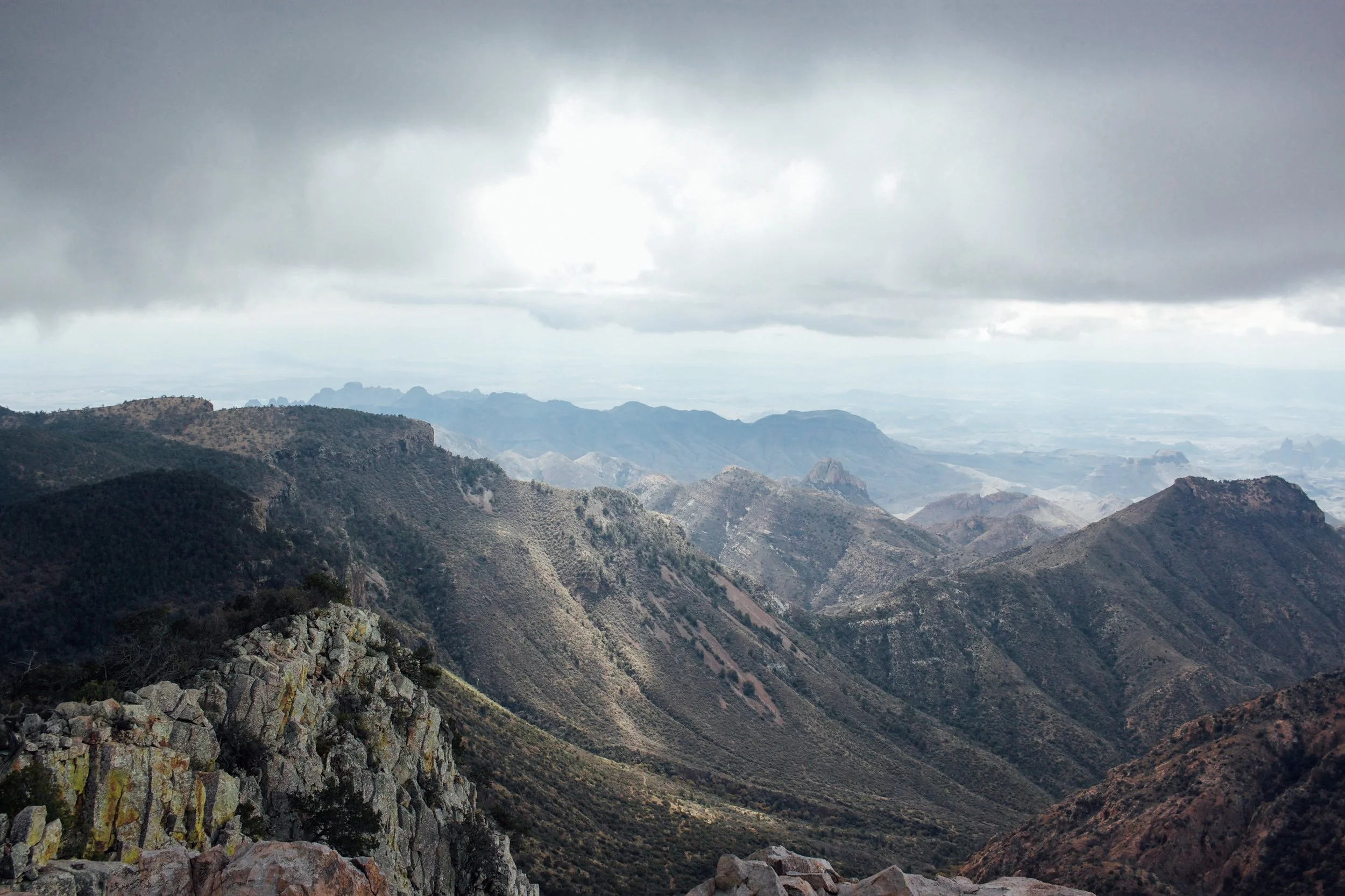
The Desert sits at roughly (VERY roughly) 3,000 feet while the Chisos Basin kneels at 5k and Emory Peak (Highest point in park) stands relatively proudly (for Texas) at 7.8k. The 2-4 thousand foot difference speaks volumes to the stark contrast of the Chisos Mountains and the surrounding desert. Rain shadow science and such create a semi oasis in the desert. Temperatures are cooler in the Chisos, terrain is steeper, and visitors are more existent. By the way, I should’ve mentioned earlier that Big Bend is way less visited than the big-hitter National Parks and exploring there will spoil the average person’s standard of isolation. Anyways, the Chisos Range is hype. Emery Peak is a must do hike as the views from the top on a clear day are truly inspiring. South Rim is one of my favorite places in the state. Standing atop the southern edge of the Chisos looking out over the iconic Elephant Tusk towards Mexico is tough to beat in Texas.

The Rio:
Driving River Road eastbound on our 3rd or 4th trip to Big Bend brought incredible new perspective of the park. The two more accessible and more visited canyons, Santa Elena and Boquillas, are phenomenal. However, to us Big Bend is all about solitude. River road is less traveled, requiring some clearance and preferably all wheel drive. The drive takes about 6 hours, but I’d recommend camping a night along the river or in the Mariscal area. Mariscal Canyon is also super epic. There’s a 7-mile round-trip hike from the Talley campground that brings you to the top of the Canyon. There’s no one out there and the overlook is incredible.

Some Last Thoughts:
People always ask us if we still like Big Bend after exploring other parts of the US, and honestly I remember sitting in Yosemite Valley for the first time wondering the same thing. Then we went back to Big Bend and concluded that Yeah… Big Bend is super gnar. The solitude is palpable and the terrain is so unique. The park is massive and you can hike wherever you want. The backcountry options are endless and I’ve met some guys from the bigbendchat.com forum that are constantly putting together epic treks. Big Bend has something for everyone.
Itinerary Advice:
Plan for 3 days minimum in the park. The place is huge and 3 days provides enough time to get a feel for the region. I highly recommend hitting the 3 regions I’ve described: The desert, mountains, and the Rio Grande. Here are some hikes and such we like in each region.
The Desert: (Time Roundtrip)
- Dog Canyon/Devil’s Den (4 hrs)
- Grapevine Hills/Balanced Rock (1 hr)
- Burro Mesa Pour Off (1 hr)
- Ernst Tinaja (0.5 hr)
- Mule Ears (1 hr)
- Exploring Mariscal Mine (1 hr)
The Chisos:
- Emery Peak (4 hrs)
- South Rim (8 hrs)
- Bottom of Cattail Falls (1.5 hrs)
- Casa Grande (Social Trail)
- The Window (1 hr)
- Boot Canyon (8 hrs when doing loop)
The Rio:
- Santa Elena Canyon (1 hr)
- Boquillas Canyon (1 hr)
- Mariscal Canyon (4 hrs)
- The HOT SPRINGS - possibly my personal favorite (5 minute walk)
When planning a trip, keep drive times in mind and always have a bunch of water with you. Big Bend can be a little intimidating. When in doubt, talk to a ranger about your plans.
As always, hit me up with any questions at callenhearne@gmail.com or the facebooks/instagrams!
